
WRF Modelling
Meteorological Modelling
AQCNZ provides meteorological datasets for air quality assessments, including CALPUFF and AERMOD dispersion modelling.
We use the Weather Research and Forecasting (WRF) model to generate project-specific weather data where suitable local observations are limited, or where a higher-resolution dataset is needed.
The data can also support qualitative dust and odour assessments where suitable local weather observations are not available and local wind patterns are important.
What We Provide
Depending on the project, our work can include:
- WRF meteorological modelling for project-specific domain
- CALWRF and CALMET processing for CALPUFF
- MMIF processing for AERMOD
- Comparison with available weather observations
- Wind roses, time-series plots and summary statistics.
Project-Specific Setup
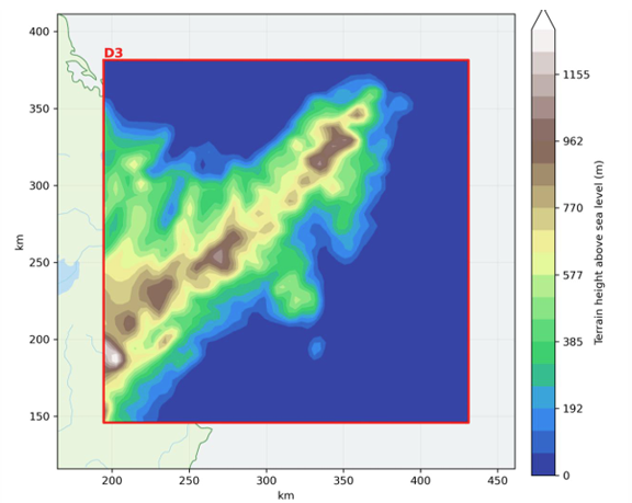
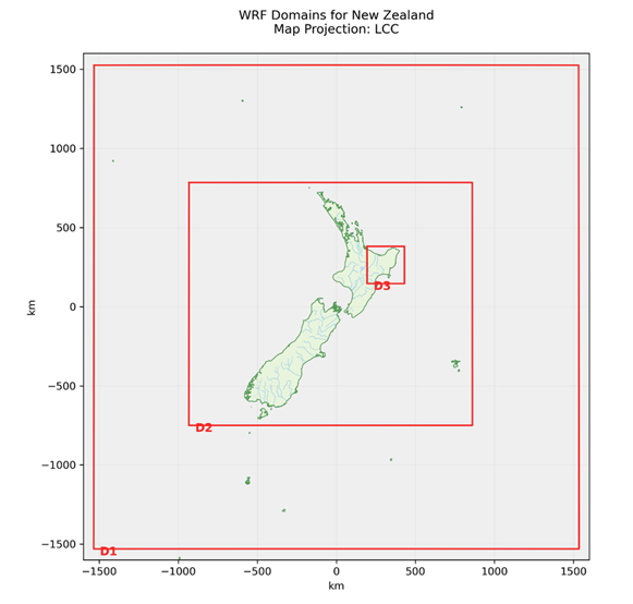
Each project uses customised nested WRF domains centred on the area of interest.
AQCNZ's standard nested domain WRF configuration progressively increases spatial resolution towards the project site, providing an effective balance between computational efficiency and the high-resolution meteorological data required for most air quality and atmospheric dispersion modelling projects.
High-resolution terrain and land-use datasets are incorporated to better represent local conditions.
WRF simulations are run in-house on AQCNZ’s dedicated high-performance modelling system, powered by an AMD Threadripper processor, allowing project-specific datasets to be prepared efficiently.
Validation
Where suitable observation data is available, we can compare the model results with a nearby weather station.
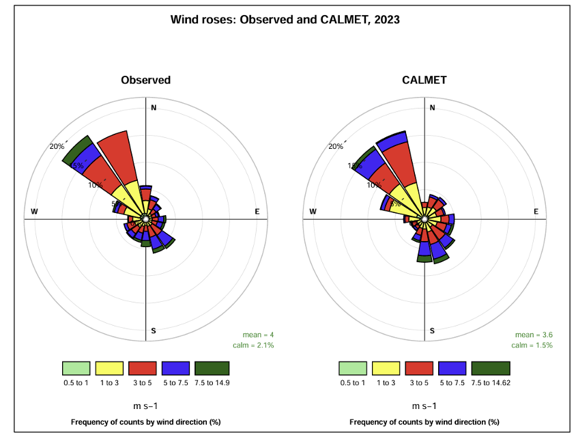
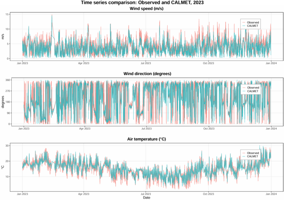
This can include checks of wind speed, wind direction, wind roses, temperature, time-series patterns and summary statistics such as bias, RMSE and Index of Agreement.
The aim is to provide a practical check that the meteorological data is suitable for the assessment.
AQCNZ uses its in-house AQCNZ Tools platform to retrieve publicly available meteorological observations, including NOAA datasets and selected New Zealand stations. These datasets are compared with WRF or CALMET outputs to assess model performance.
Typical Outputs
Typical outputs include:
- WRF output files
- CALMET files for CALPUFF
- AERMOD-compatible meteorological files
- Domain maps
- Terrain and land-use maps
- Wind rose comparisons
- Time-series plots
- Short validation summary or technical note
Indicative Pricing
| Package | Includes | 1 Year | 2 Year | 3 Year |
|---|---|---|---|---|
| Data Package | WRF modelling and processed meteorological files for CALPUFF or AERMOD (4 km Grid Resolution (50 km x 50 km) | From NZ$1,750 | From NZ$2,000 | From NZ$2,250 |
| Validated Package | Data Package plus comparison with one nearby observation station, including wind rose comparisons, time-series plots and summary statistics. | From NZ$2,750 | From NZ$3,000 | From NZ$3,250 |
Validated Package pricing assumes suitable local observation data is freely available.
Prices exclude GST.
Pricing for larger domains, finer model resolution, additional validation stations, or more than 3 years of data is available on request.
